What people mean by “agricultural appraisal”
It is one of the most common things people type before they find me, and it turns out to mean at least four different assignments.
A house on land. Ten acres in Parker County with a home on it, being sold, inherited, divided or refinanced. The highest and best use is residential; the ground just happens to be large. This is the most common version by a wide margin, and it is squarely residential appraisal work.
Bare residential land. A homesite, a few acres someone is buying to build on, a tract being split off. Also residential, provided its highest and best use is one-to-four family.
A tax question. Someone whose land carries a 1-d-1 open-space valuation, worrying about what happens when the use changes. That is a question about the appraisal district's productivity valuation, which is a different exercise from market value entirely — though the consequences are real and are covered below.
An actual farm or ranch. Land whose highest and best use is agricultural production, valued as an agricultural enterprise. That is Certified General work and I decline it. My credential covers one-to-four unit residential property and residential land, and taking a working ranch outside that scope is how an appraiser gets a competent report thrown out on a technicality.
So this article is about the first two, which is most of what people actually have. If you have the fourth, you want a Certified General appraiser, and saying so is not modesty — it is the whole reason the rest of this is worth reading.
What is in the sample
Every closed land sale I could assemble from NTREIS for the three years ending September 2026 across Tarrant, Parker, Hood, Johnson, Ellis, Wise and Denton counties: 5,671 closed sales, drawn from 18,153 listings taken over the same period. Land leases are excluded. Tract sizes run from a tenth of an acre to several hundred.
That second number matters as much as the first, and we will come back to it.
An acre is not an acre
The single most common error I see in rural valuation — in listings, in tax protests, in owner expectations, and in the occasional appraisal — is taking a per-acre figure from one tract and applying it to a different-sized one.
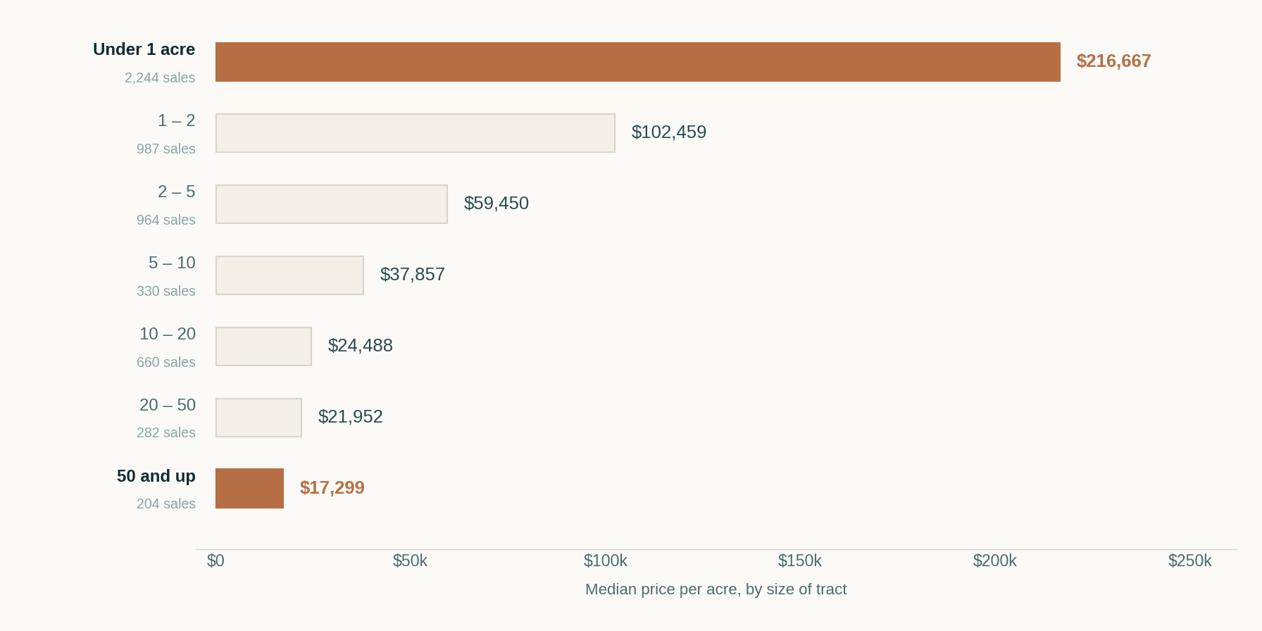
From the smallest parcels to the largest, the per-acre figure falls by a factor of more than twelve. And this is not a story about location: it holds inside every county in the sample.
Put a model on it and the relationship is remarkably regular. Across all 5,671 sales, controlling for county, doubling the size of a tract raises its total price by about 52%. Not 100%. Which means the price per acre falls by roughly a quarter every time the tract doubles.
The reason is that a parcel is not a pile of interchangeable acres. The first acre carries the road frontage, the utility connection, the septic area, the building site — everything that makes the parcel usable at all. Acres eleven through twenty carry none of that. They add room, and room is worth something, but it is worth much less per unit than access.
If a neighbor's two acres sold for $60,000 an acre, your twenty acres are almost certainly not worth $1.2 million. The defensible comparison is to other twenty-acre tracts — and where those do not exist, to a per-acre figure explicitly adjusted down the size curve, with the adjustment shown.
Why a house on acreage breaks price per square foot
Everyone reaches for price per square foot. On a subdivision street where the lots are all a tenth of an acre, it is a reasonable shorthand, because the land is a constant and the house is the only thing that varies.
On acreage it falls apart, and here is the proof. This is the same analysis run on 89,302 residential closings, restricted to houses of 1,800–2,600 square feet so the house itself is roughly held still:
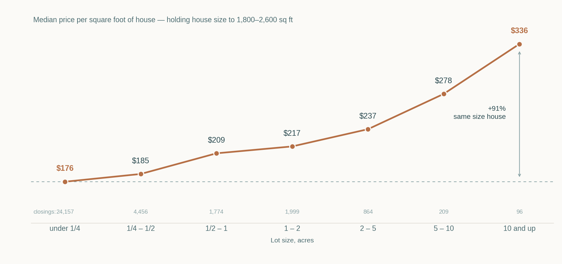
A 2,200-square-foot house on a tenth of an acre trades at about $176 a foot. The same house on ten acres trades at about $336. The house did not get better. The buyer is paying for the ground and it lands, arithmetically, on top of the house.
So when someone tells you rural property “sells for more per foot,” they have not found a premium. They have found land, expressed in the wrong unit. The correct move is to value the site separately and the improvements separately — which is what an appraisal does and what a per-foot comparison cannot.
What a school district does to bare land
This one surprises people, because bare land has no children in it. But land is bought by people who intend to build, and what they intend to build into is a district.
Parker County has enough land sales to measure it properly. Holding tract size and date of sale constant, against Weatherford ISD as the baseline:
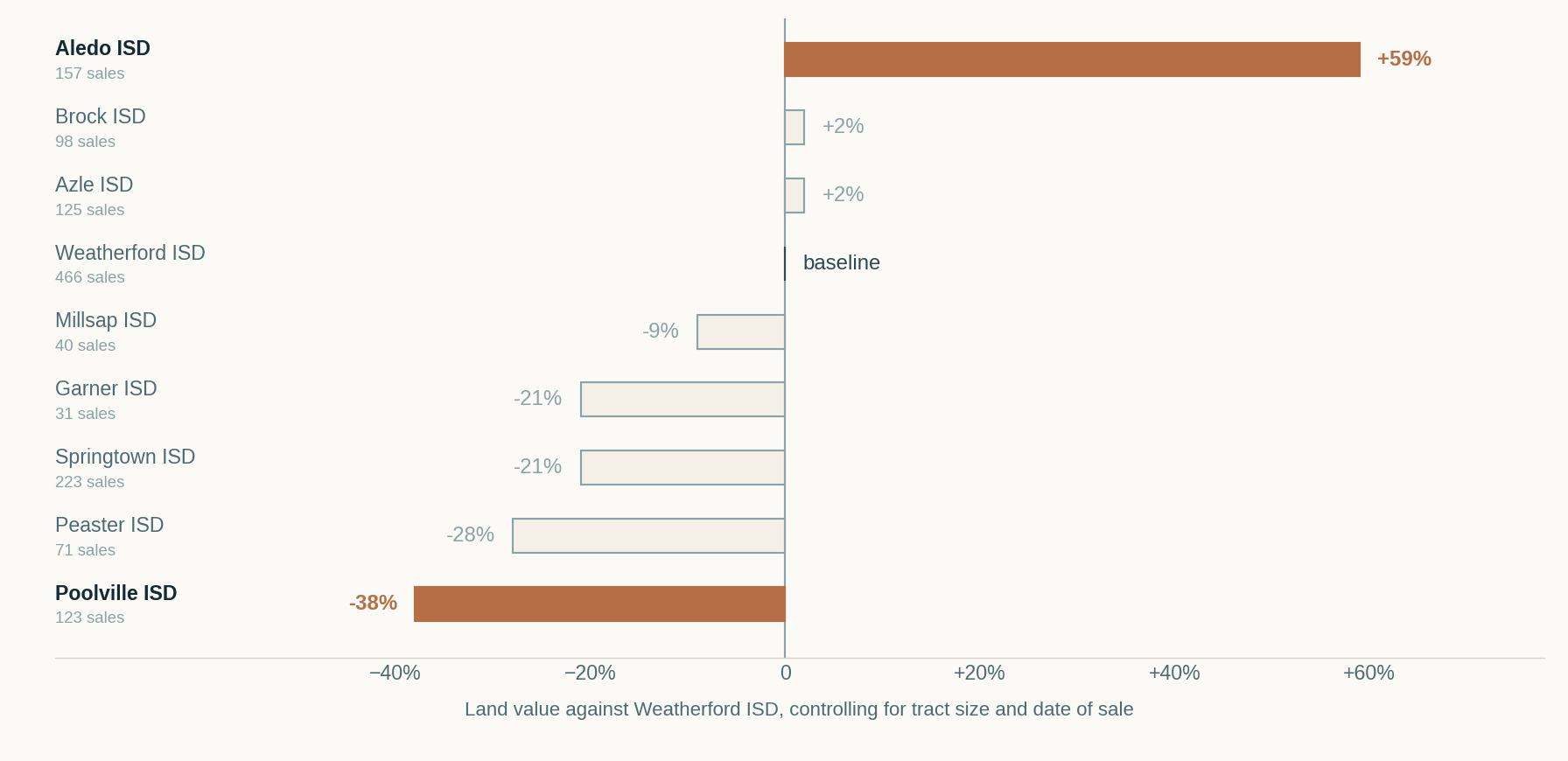
Aledo ISD land runs about 59% above Weatherford, Poolville about 38% below — a spread of better than two to one for dirt in the same county, often within twenty minutes of each other. Brock and Azle are indistinguishable from Weatherford; Springtown, Peaster, Garner and Poolville all sit well under it.
The same pattern appears in the other counties, and harder. In Tarrant, against Fort Worth ISD, land in Carroll ISD runs several times higher and Grapevine-Colleyville not far behind. In Johnson County, land in Burleson ISD runs about 85% above Cleburne, Joshua about 70% and Alvarado about 40%.
The practical consequence: a land comparable from ten minutes away can be the wrong comparable, and the boundary is invisible on the ground. Confirming the district for the specific parcel is not a formality.
Acreage is not usable acreage
Everything so far has treated an acre as an acre within its size band. It is not, and the difference has a formal name.
Highest and best use is tested four ways: legally permissible, physically possible, financially feasible, and maximally productive. The second test is the one this section is about. A parcel's shape, its topography, where the water sits, where the drive runs and where the existing improvements already stand together determine how much of the ground can actually be built on or used — and buyers price that, not the deed acreage.
Some of it is measurable. Tagging the closed sales by their listed lot characteristics and holding acreage, county and date constant:
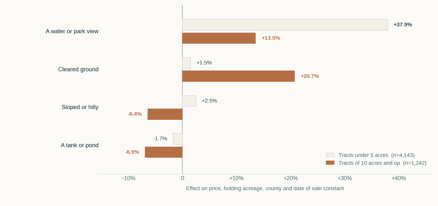
The effects invert with size, and the inversion is the finding.
On a homesite, buyers are paying for outlook. Under five acres a water or park view carries +37.9% (p < 0.001), while cleared ground, slope and a pond are all statistically indistinguishable from nothing. Almost any small tract can hold a house, so what separates them is what you see from it.
On acreage, buyers are paying for workable ground. At ten acres and up, cleared land carries +20.7% (p < 0.001), slope costs about 6% (p = 0.080) and a tank or pond costs about 7% (p = 0.003). The view premium falls to +13.5% and weakens.
The pond result is worth pausing on, because it is counterintuitive and it is the clearest one in the set. On a small lot a pond is scenery and prices as roughly nothing. On a large tract it is often sitting on the flattest, most accessible part of the parcel — the part a buyer intended to put a barn, an arena or a second structure on — and the market discounts it accordingly.
Where the measurement stops
Having found that much, I went looking for the rest of it and did not find it, which is worth reporting.
I built a “usable” flag — cleared or level or pasture, and not irregular or sloped — and crossed it with the view tag to test whether a usable tract with a view behaves differently from an unusable one without. The interaction came back +12.5% with p = 0.273. Nothing. And the Irregular Lot tag on its own predicts essentially nothing anywhere in the data.
That null result is the substantive point rather than a footnote. The tag records that a parcel is irregular. It does not record that the drive runs down the spine of the only level ground, that the flat area is four disconnected pieces rather than one, that the pond sits where a structure would go, or that the buildable portion faces away from the view. And it certainly does not know what the buyer intends to do with it.
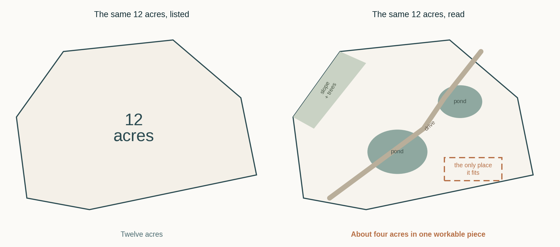
Because that is the crux: usable area is not a property of the land. It is a property of the land and the intended use together. Twelve acres broken into four workable pieces is generous for a house and a shop and unworkable for a riding arena. The same parcel is two different quantities depending on the question asked of it.
Which sets the scope of work. Aerial imagery, FEMA flood mapping, soil survey and topographic data narrow the questions — they will tell you where to look and what to ask. They do not answer them. The inspection does, and a report on rural property should state what portion of the tract was treated as usable and why, rather than carrying a per-acre figure applied across the whole deed description as though every acre were the same.
Two tracts of identical size in the same district can differ by a quarter or more on the basis of how much of the ground works. That is larger than most of the adjustments in a typical grid, and it is invisible in the acreage figure everyone quotes.
The hardest thing to sell, and the fastest to appreciate
Two facts about land that sit oddly together.
The first is that most of it does not sell. Of 18,153 land listings taken since January 2023, only about 31% closed. The rest expired, were cancelled or were withdrawn. For comparison, the residential failure rate across the markets I track runs closer to one in five. Land is roughly three times harder to move.
The ones that do sell take their time and give up ground: a median 69 days on market, closing at 90.9% of original list price. Houses in the same window close at about 97%. And time on market rises with size, from a median 56 days under two acres to about 100 days above twenty.
| Tract size | Median days on market |
|---|---|
| Under 2 acres | 56 |
| 2 – 5 acres | 89 |
| 5 – 10 acres | 86 |
| 10 – 20 acres | 87 |
| 20 acres and up | 100 |
The second fact is that land has been the strongest-performing residential asset in this market. Controlling for tract size and county, land values are up about 6.3% a year across the window — and that holds county by county: Parker +6.1%, Hood +7.2%, Johnson +7.1%, Tarrant +7.1%.
That pooled figure hides a great deal, and the dispersion between towns is wider than the dispersion between years. Over the same window, land in Weatherford rose about 14% a year (n=682, p < 0.001) while land in Springtown, twelve miles away, fell about 6% (n=279, p=0.023). Granbury ran about +9%. The county and pooled figures are averages across very different submarkets and should not be applied to a particular parcel.
Set that against the houses. In a study of 40,703 closings across nineteen markets, houses on subdivision lots have been falling about 1% a year while houses on an acre or more have been rising. The land is doing the work in both datasets.
Which is the useful reconciliation: land is illiquid and appreciating at the same time. A thin market with few buyers can still be a rising one, because price is set by the few transactions that happen rather than by the many that do not. For an owner that means patience is the price of the appreciation. For anyone valuing it, it means the comparable set is small, old, and has to be adjusted carefully for time.
The ag exemption, and the bill that follows it
A large share of rural land in these counties carries what everyone calls an “ag exemption.” It is not an exemption. It is an alternative basis of assessment — 1-d-1 open-space valuation — under which the appraisal district values the land on its capacity to produce agricultural products rather than on what it would sell for. The tax bill can be a small fraction of what market value would produce.
Two things follow, and both bear on value.
It is a productivity value, not a market value. The figure the appraisal district carries is not an opinion of what the land is worth, and it is not evidence of market value in a divorce, an estate or a protest. Those are different exercises with different definitions.
Changing the use triggers a rollback. When land comes out of agricultural use, the taxing units recapture the difference between what was paid and what would have been paid at market value. Since HB 1743 took effect on September 1, 2019, the recapture covers three years with 5% interest, down from five years and 7% before. That is materially lighter than the old rule, but on a tract with a large gap between productivity and market value it is still real money, and it lands on whoever owns the property when the use changes.
For an appraisal, the rollback is generally not part of the opinion of value, but it is a condition of sale that market participants know about and price into what they will pay. It belongs in the analysis, and it certainly belongs in a conversation before someone buys.
How I actually value a rural property
The method follows from everything above.
- Value the land separately. From tracts of comparable size, in the same district, adjusted along the size curve where they are not. A per-acre figure lifted from a differently sized tract is the single most common defect I see in rural work.
- Establish what portion is usable, and for what. Floodplain, slope, timber, water, road frontage, where the drive and existing improvements sit, whether the workable ground is contiguous, and whether the parcel can be divided. Twelve acres of pasture and twelve acres of bottomland are not the same twelve acres, and the market prices the difference at more than twenty percent.
- Treat the outbuildings as contributory, not as cost. A barn, a shop, an arena, fencing and a pond each contribute what a buyer will pay for them here, which is usually well below what they cost to build and occasionally near zero.
- Confirm the district, the utilities and the access. Well or public water, septic type and condition, the electric service, road frontage and whether the access is deeded or a handshake.
- Check the ag status and the rollback exposure, and say plainly whose problem it is.
- Do not use price per square foot. Not as an analysis, not as a check, and not in the reconciliation. The chart above is why.
- Expect thin data, and say so. With a 31% sale rate and a wide size distribution, clean paired sales frequently do not exist. When they do not, the report should say which secondary method carried the adjustment.
What this does not say
These are medians, not appraisals. Every figure here is an aggregate across seven counties and three years. No specific parcel is likely to sit on any of these lines, and the spread within each band is wide.
Size bands get thin at the top. The 20–50 and 50-plus acre bands rest on 282 and 204 sales respectively — enough to trust the shape of the curve, though the figures at the far end remain the least precise in the set.
The lot-feature tags are crude. They are entered by listing agents, applied inconsistently, and describe the parcel rather than its fit for any particular use. The measured effects above are real but they are a floor on how much usability matters, not a ceiling.
Three years is a short window. The +6.3% trend describes 2023 through 2026 and should not be extended in either direction.
And none of it is agricultural valuation. Land whose highest and best use is agricultural production is appraised by a Certified General appraiser, using methods this article does not cover.
Terrence Bilodeau is a Certified Residential Appraiser (TX-1360232) and a Texas real estate broker. Clearfork Appraisals provides private-client appraisals in Fort Worth and across Tarrant, Parker, Johnson and Hood counties. This article is a general market study. It is not an appraisal, not tax advice, and not a valuation opinion about any specific property.
- North Texas Real Estate Information Systems (NTREIS) land and residential listings and closed sales, Tarrant, Parker, Hood, Johnson, Ellis, Wise and Denton counties, September 2023 – September 2026. Author's analysis; figures reported in aggregate.
- Texas A&M AgriLife, Texas Agriculture Law — 2019 legislative recap (HB 1743: rollback reduced to three years at 5% interest, effective September 1, 2019)
- TALCB — Appraisal, Evaluation, Broker’s Price Opinion: What’s the Difference?
Statutory and tax references are general information, not tax advice. Rollback exposure, agricultural qualification and district boundaries are specific to a parcel and change over time; confirm current figures with the county appraisal district and your tax advisor.